East Coast
East Coast
The East Coast of Tasmania is where Tasmanians go to relax. With the biggest town having a population of 2000 people and all the rest under 1000, the only place you may find any hustle and bustle is at the boat ramps.
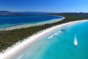
With two beaches being voted amongst the best in the world, why don't you put on your judges hat and try and work out which ones. Your work will be cut out for you with so many beautiful beaches to choose from.
The ocean isn't just for admiring and recharging by, it has treasure galore, with small fishing fleets bringing in just caught crayfish, scallops, abalone, and fish. Oyster farms are also found on the East Coast, taking advantage of the pristine environment. As a result, many local restaurants have beautiful seafood dishes. And of course, fresh fish and chips by the beach is hard to pass up.
If you want to have a try at fishing, you can have a go from jetties and boat ramps, the beach itself, or hire a tinnie (a little boat). If you dream of catching the big one, go on a charter boat with a professional who has experience with gamefishing and where and how to land tuna and marlin, as well as reef and deep sea fishing.
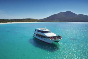
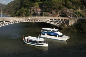
If you fancy a water based adventure without casting a line, there are canoes, kayaks and paddle boats for hire. Or sit back and enjoy an unforgettable cruise of Wineglass Bay or Maria Island with its sea caves, spring fed waterfalls, sweeping sandy beaches and cliffs.
Underwater adventure is available with some of the best temperate water diving to be found.
If you need a break from the seaside there are always vineyards to be found, and Kate is always happy to see you at her berry farm, situated just 1.5km south of Swansea, where you can enjoy berry icecreams, sauces, jams and more.
Three National Parks are found on the East Coast, each with something unique to offer. They are Douglas-Apsley National Park, Freycinet National Park, and Maria Island National Park. The main towns from North to South are St Helens, St Marys, Bicheno, Coles Bay, Swansea, Triabunna, and Orford.
St Helens
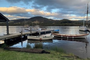
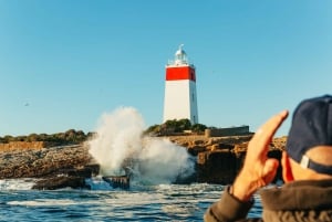
St Helens (population approx. 2000) is tucked in at the end of Georges Bay. It harbours the State's largest fishing fleet, which means good eating. Kayak and aluminium dinghy hire is available as well as game fishing charters. Walking tracks are found each side of Georges Bay. St Helens is the gateway to Binalong Bay and the Bay of Fires. So there is no shortage of places nearby to beachcomb, snorkel, surf, dive, hunt abalone or simply cast a line. The region is known for having winters that are warmer than most of the State.
St Helens Visitor Information Centre: 61 Cecilia Street
Ph: +61 3 6376 1744
Bicheno
Bicheno (population approx. 650) is a fishing port and relaxing beach resort, with crayfishing being the largest industry. Fishing charters, boat trips, fairy penguin tours, dive excursions are all available here. A nice way to see the town's coastline is to take the Foreshore Footway, which covers 3.5km of the coastline. A picturesque section looks across The Gulch to Governor Island. The northern end of the Gulch is a marine reserve with dive trips or glass bottom boat tours available to take you there. Nearby is a 160 acre nature park with hand feeding of kangaroos and viewing of Tasmanian Devils and other native animals.
Bicheno Information Centre: 41b Foster Street, Bicheno
Ph: +61 3 6375 1500
Coles Bay
Coles Bay (permanent population less than 500) is found 31 km off the Tasman Highway, and is a stones throw from the Freycinet National Park. It is approx. two and a half hours drive from both Launceston and Hobart. Sheltered on an inlet ideal for fishing and other water recreation, it is no sleepy hollow come summer holiday season. It contains all essential services, with much of the accommodation for visitors to Freycinet National Park found here. You will find operators based here that hire bikes, kayaks, 3m dinghies, fishing gear, snorkelling gear, and bikes. Tours that take you out on quad bikes, cruises to Wineglass Bay, or to seal colonies on Schouten Island. A marine farm where you can enjoy oysters, mussels, scallops and rock lobster (in season). An airstrip at nearby Friendly Beaches has scenic flights to appreciate the East Coast from the air. For information on walks found in the Freycinet national park.
Visitor Information: Freycinet National Park Office (just inside entrance to national park)
Phone: (03) 6256 7000
Swansea
Swansea (population 500+), lies on the western shore of Great Oyster Bay with views to the mountains of Freycinet Peninsula. A heritage walk booklet is available locally as a guide to the colonial heritage. Most of the heritage buildings are found along the waterfront on Franklin Street. Take in the stunning coastal scenery on a 40 minute stroll around the Swansea headland, which offers signage about the significance of the area for Aboriginal people. Named the loon.tite.ter.maire.re.le.hoin.er cultural trail. after the local band of Aboriginal people, this track takes you from Waterloo Beach to Schouten Beach. It passes through a shearwater (muttonbird) breeding area. These remarkable migratory birds use burrows in which to breed. The birds can be seen at dusk in the summer months when they return to their burrows after feeding at sea.
The Swansea Bark Mill is a fully restored and working black wattle bark mill which demonstrates how bark from local black wattle trees was once crushed for export across the world. The bark is the basic ingredient used in tanning.
Spiky bridge is found 7.5km south of Swansea. It was built by convicts in 1843, and on seeing it, the origin of the name is no mystery.
Mayfield Bay Conservation Area is 15km south of Swansea. It is a popular free camping spot, to enjoy, fishing, swimming, snorkelling, or just relaxing, with open fires allowed in the fireplaces. A very short walk from the camping area and you come to Three Arch Bridge. built by convicts around 1845. The current road passes over the top. You can walk through the arches, and marvel at the hard work involved in such a task. A warning for the tall though, the walk from one side to the other is about 20 metres and the height does decrease so mind your head!
Triabunna
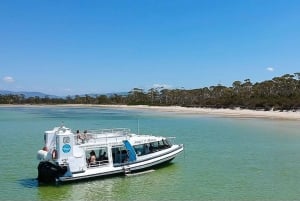
Triabunna (Population 700+) is set on an inlet of Spring Bay, whose sheltered waters are ideal for sailing and fishing. Just over an hours drive from Hobart, this scenic township is surrounded by nearby beaches, hills and beautiful tracts of eucalyptus forest. Forestry is a main employer in the area, as evidenced by the woodchip pile on the northside of the bay. The area has historic buildings from Tasmania's colonial period. The town also commands excellent views of Maria Island, which can be reached by a short ferry ride from Triabunna. Eco cruises of the island also leave from here, which can be combined with a visit to Darlington Vineyard. The area has an information centre located at the town's Marina. Local walks include the Pelican Walk which begins near the Marina. The bulk carrier the Troy D was purposely sunk as a dive wreck and charter dives are available.
Well regarded Spring Bay Seafoods is located just 4 kilometres from the township and sells its scallops and mussels direct to the public.
The coastal drive between Triabunna and Swansea is a real treat.
Triabunna Visitor Information Centre: Corner Charles Street and Esplanade, Triabunna
Phone: +61 3 6257 4772
Orford
Orford (population 450+), some 78 kilometres northeast of Hobart, is centred around the mouth of the Prosser River, on Prosser Bay. Beyond this bay are the waters of the Mercury Passage, with Maria Island providing a spectacular backdrop to the view. Beaches worth spending time at include, running north to south, Raspins Beach, Millingtons Beach, Spring Beach and Rebhan Beach. The Thumbs Look out and Wielangta Forest are nearby. Spring Beach and Rebhan Beach can be visited on the way to Weilangta Forest by driving south on Charles Street which becomes Rebhan Road. When this meets up with Weilangta Road continue south for the forest drive. On the return to Orford stay on the Weilangta Road and you will go via The Thumbs Lookout. From the lookout, there is a 2 hour walking track to The Thumbs for the energetic. If heading to the lookout from town, go south on Charles Street, and turn right on to Weilangta Road. When we visited, the only signage for the turnoff to Weilangta Road said, "Quarry". The Convict Walk commences on the northside of the Orford Bridge and runs west along the Prosser River. This road was built by convicts and doesn't actually lead anywhere, but is now good for a pleasant stroll along the river. A cycle/walking track has commenced construction and currently runs from the Orford Bridge around to Raspins Beach. It will eventually link Triabunna to Spring Beach. There's a 9 hole golf course on the Tasman Highway and Our Park is a great place to take the kids for a BBQ. Our Park has toilets and shelter and is near Millingtons beach. Paddle Boats are available for hire on the Prosser River, in holiday season.
Visitor Information Centre at Triabunna (9km north of Orford): Corner Charles Street and Esplanade, Triabunna
Telephone: +61 3 6257 4772
Photo credits:Seal colony courtesy Tourism Tasmania & East Coast Cruises; Grapes courtesy Fabio Ingrosso,flickr.com/people/30863627@N03; Zoanthids Parazoanthus sp. courtesy Neville Colemnan; Tasmanian Devil, MDT, Wineglass Bay, MDT; Swansea, amorris General Store, courtesy vitualsteve Wikipedia; Spiky Bridge, MDT; Dive site "Troy D" courtesy Mick Davis troyd.com.au; Maria Island, MDT