Western Wilderness
Western Wilderness
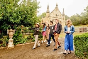
With no road access to the West Coast from southern Tasmania until the 1930's, and no way out north by road until the 1960's, those of the West Coast were a hardy, independent type. The feeling of isolation and remoteness remains. With winding roads in and out, dense bush by the road's edge, and at times wild weather, you can't help but spare a thought for the early settlers, many of whom found themselves in this rugged wilderness due to work in mining, or the early timber industry. Or the unfortunate convicts who found themselves sent to Sarah Island in Macquarie Harbour, to face the harshest of conditions. For us not doing the hard yards of the early pioneers or convicts, the appeal of the West Coast is in its isolation and wild beauty. There are remote railway rides, river cruises, whitewater rafting, sailing, jet boating, 4WD and quad bike tours, helicopter flights, bush walking, fishing, horse riding, and sand dunes to walk (or sand board).
There are six towns on the West Coast, most of which grew up around mining deposits, which saw large influxes of workers and their families during boom times. Now the heydays are past, with the feeling that the towns and people may make an impact for a while, but the ruggedness of the area will always come out on top. Even now, you would be lucky to find a sealed road, heading off the main highway, but for the hydroelectric stations and dams in the area. The towns of the West Coast in order of population size are: Queenstown, Rosebery, Zeehan, Strahan, Waratah and Tullah. Names you will hear of towns that once were are: Dundas, Williamsford, Linda, Pillinger, Luina and Savage River.
Waratah
Waratah (population about 300) is an historic mining town that at one time was considered the richest tin mine in the world. Tin was discovered by James "Philosopher" Smith at the nearby Mt Bischoff in 1871 and the original mine closed in 1935 having produced 81,000 tonnes of tin.
Philosopher Smith is seen as the pioneer of mining on Tasmania’s West Coast and his discoveries were invaluable to the state’s economy. A replica of his hut sits next to the Waratah Museum, giving an insight into the conditions of miners during those early days.
At its peak the town boasted a population of 5000 and despite its isolation lays claim to having the second Tasmanian hydroelectric scheme and St James Anglican Church was the first church in Tasmania to be lit by hydro power.
Today Waratah is a peaceful little town with beautiful sights, historical attractions and stunning walks. Lake Waratah is set in the middle of town and then flows over the Waratah Falls, which are lit up of a night.
There are a number of walking tracks in town with destinations including the bottom of the falls, the old hydro site and Mt Bischoff.
Attractions include Mt. Vista Golf course, the Waratah Museum, the Kenworthy Stamper Mill and the Tarkine Interpretation Centre and Gallery.
Accommodation is available at the Waratah Hotel and the local council runs a very nice camping ground for caravans and campers with a good range of facilities.
November and December is a great time to visit this area with the waratahs that the town is named after in bloom.
Tullah
Tullah (population about 250) is a town that has seen plenty of action in the past. The action now can be water based, with Lake Rosebery and Lake Mackintosh nearly surrounding the community, with bridge crossings on either side of town. In an area rich in minerals, Tullah started out life servicing the Mt Farrell silver lead mine, which began operating in 1898. It closed in 1932, but the nearby North Farrell Mine opened in 1934 and operated up until 1974. With the Hydro Electricity Commission building dams in the region, from the 1970's through to the 1990's Tullah expanded to accommodate the construction workforce, with up to 800 workmen in town. The Tullah Museum has information and displays on the hydroelectric projects that were built and now generate power (currently in the process of being rehomed).
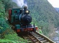
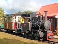
Tullah is home to the steam engine Wee Georgie Wood. A narrow gauge tramway was Tullah's link to the outside world from 1924 until 1964 when a road was finally established. The two foot wide railway was used to haul ore on a 10km journey to connect up with the larger gauge Emu Bay Railway. After years of disuse, the locomotive Wee Georgie Wood and 1.6km of track were restored, and opened to the public in 1987. At present Wee Georgie Wood is undergoing repairs to his boiler, so a 1925 Romeo mechanical locomotive used on the Lake Margaret tramway, has come out of retirement from the West Coast Pioneers Museum. Rides take place form 10am-4pm on the first Sunday, plus last Saturday and Sunday of the month from October to June.
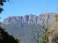
If you have energy to burn, you can time a visit in November to coincide with the annual Tullah Challenge - a run, bike and paddle around the area. If a hike is more to your liking, you can climb Mt Farrell (712m, 3 hr return) which has good views of Mt Murchison, little Lake Herbert and big Lake Mackintosh. For a walk so close to a town and main highway, you are well rewarded with natural beauty. If you are looking for a more challenging hike Mt Murchison (1061m, 5 hours) is nearby. The walk is signposted, starting from the Anthony Road which is just south of Tullah and connects Tullah to Queenstown. I climbed it years ago, and remember there being a couple of pretty steep sections. I also remember some awesome views.
Rosebery
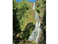
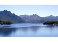
Rosebery (population about 1000) has a mine that produces zinc, lead, silver, copper and gold. It is surrounded by temperate rainforest, and sits in a valley in the shadow of Mt Black. From the picnic area at the southern end of town, a short walk can be taken along the Stitt River to Stitt Falls. Though nice, they pale in comparison to the mighty Montezuma Falls, which at 103m are Tasmania's highest. Head south out of Rosebery and the signposted turnoff to the left is seen after about 2km. Follow this for about 6km to its end, which is where the town of Williamsford once existed. The 3.5km walk, through rainforest is well worth the time. It is a flat, easy walk, following a track that was the route of the North East Dundas Tramway from 1889-1925. The tramway went from Williamsford to Zeehan. There is a viewing platform, at the base of the falls and a rope and wire bridge across the river. An aerial ropeway was constructed in the 1930's and operated until 1968, to bring ore from the Hercules Mine at Williamsford to be processed at Rosebery, the remains of which can still be seen.
Close to Rosebery is Mt Read. Known for its high rainfall (approx. 3.3m/year), but also residence to what may be the oldest living plant on earth. A stand of Huon Pine trees are thought to have been living here for more than 10 000 years. Though not open to the public, the area is able to be visited on a guided tour (see Lake Johnson Reserve Tour). Trout fishing tours can also be arranged from Rosebery, including to Lake Pieman and Lake Rosebery.
For me, a treat of this area is the drive from Rosebery to Tullah. Up and over the forested Mt Black, it's one of those few places you can feel like a racing car driver whilst sticking to the speed limit. With tight bends and curves, and a beautiful vista of Mt Murchison, it's no surprise the car rally event Targa Tasmania includes roads down here.
Zeehan
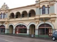
Zeehan (population 900) is a town with a big past! Silver and lead were discovered in 1882, which led to the town becoming home to 10 000 people, 27 pubs and its own stock exchange. The Gaiety Theatre, once Australia's largest concert hall was built in 1899, with a seating capacity of 1000! Boom times lasted up until the First World War. Mining continues to play a role in the life of the town, with the Renison Bell Mine nearby, whose fortune waxes and wanes depending on the world price for tin.
The West Coast Pioneers Memorial Museum is on Main Street, and is one of the best regional museums in Australia. It showcases the history of the West Coast, with displays and information about mining and minerals, rail and shipping. Examples of the mineral emblem of Tasmania, crocoite, which is only found in this area, can be seen, as well as early steam locomotives and carriages. Photographs and early mining equipment, help give a feel for life in the pioneering days.
Near the golf course is the Spray Tunnel Loop. This 4km gravel track can be walked or driven. It passes through the 100m Spray Tunnel (height 3m, width 2.2m) and the entrance to the abandoned Spray Silver Mine.
For a challenging hike Mt Zeehan (height 702m, 3hrs return) can be climbed. Drive nearly 3km along the road to Strahan, passing the old smelter site on the left. Look for a 4WD track off to the right. Depending on your vehicle you can start walking here, or further up the track, where it comes to a small creek crossing.
Trial Harbour is found on the ocean about 23km west of Zeehan, and sits at the northern end of Ocean Beach. It consists of about a dozen shacks and is popular with fishermen, surfers and trial bike riders. It has a camping area, and small, free local history museum. Granville Harbour is 38km northwest of Zeehan, with holiday shacks and good fishing. On the way to it from Zeehan you pass the Reece Dam, if looking to do a spot of trout fishing. Or you can stop to take a one hour return walk to Heemskirk Falls found on the Heemskirk River, about 19 km from Zeehan.
Queenstown
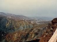
Queenstown (population 2500) is a town with a history of continuous mining dating back over a century. The ravages of early mining took their toll on the surrounding hillsides leaving them devoid of vegetation and Queenstown became well known for its "moonscape". The early copper mining led to trees being chopped down to feed the smelter. The sulphur laden fumes killed off the remaining vegetation, with heavy rain removing the vulnerable topsoil, destroying any chance of natural regrowth. Work has been undertaken over the last two decades to reforest the bare hills and improve the quality of the nearby rivers where mine tailings were dumped for decades. The copper stained slopes are best viewed from the Spion Kopf lookout. The thirty minute return walk is steep in places, and starts from Latrobe Street. The Iron Blow viewing platform, off the Lyell Highway at the top of Gormanston hill has amazing views also. Iron Blow is where mining first started in the region. Mt Lyell Enviro Tours look at the open cut mining that's taken place and remediation. You can experience the working, modern underground mining operation by going on a Mt Lyell Underground Mine Tour.
Railway was essential in the early days to transporting the ore out. An engineering marvel, it initially connected Queenstown to the then port of Teepookana on the King River, and later to Strahan. The 35 kilometre journey crossed 40 bridges, and eight kilometres needed the Abt rack and pinion system to be able to negotiate steep inclines and declines that would otherwise be too steep for a train. This involves having a toothed rack/rail in the middle of the two conventional rails, which fits with a geared pinion wheel on the locomotive. The Abt Railway, as it was always known by the locals, closed in 1963. Excitingly, it has recently been fully restored, and The West Coast Wilderness Railway can be taken as a return journey, or one-way from both Strahan and Queenstown. At the Queenie end, the station has a room with photos and info on the rack and pinion system.
In Queenstown itself, the Empire Hotel is one of the original 30 hotels! Built in 1901, it has a carved Tasmanian Blackwood staircase. The Eric Thomas Galley Museum, on Driffield Street, has photos and other memorabilia of early pioneer life. It also doubles as the Visitor Information Centre. Across the road is the Miner's Siding, erected to commemorate 100 years of mining. Nearby is the library, with historical information on Queenstown and surrounding areas. This also has an online access centre.
On Penghana Road, is a National Parks and Wildlife office where you can obtain passes for entry to National Parks, good maps and information on walks and four wheel drives in the area. Close to Queenstown is Lake Burbury, known for its great trout fishing. It has a picnic area and campsite (water, toilets, gas bbqs). Another great view of the lake is obtained by heading south out of Queenstown on Conlan Street, and onto Mt Jukes Road, where there is a lookout before the road descends to the lake. Along the road, a stand of Huon Pine and King Billy Pine is accessible via a platform. The bitumen ends at the lake with the unsealed road (last 3km 4WD only) continuing on to a car park at the start of Bird River Walk (3-4hr return, 7.5km). This flat walk follows what was a railway for the Mount North Lyell Company which terminated at the Port of Pillinger, on the shore of Macquarie Harbour. A few ruins are all that remain of a company town that once housed up to a thousand people.
Strahan
Strahan (pronounced Strawn, population around 700) is a place of natural beauty and though relaxed, hums along with activity, especially at peak visitor times. Nestled on a northern reach of the Macquarie Harbour, it is the starting point for cruises to the mirror calm, highly reflective waters of the lower Gordon River which are a major drawcard of the region. There are luxury catamarans, yachts, jet boats, seaplanes and kayaks to explore the harbour on, which is six times the size of Sydney Harbour. A small fishing fleet operates from here seeking out abalone, crayfish and shark. On the harbour there are some commercial fish farms of rainbow trout and Atlantic salmon. It is also a departure point for the West Coast Wilderness Railway, and 4WD tours. A unique experience is the Piners and Miners tour, where the 4WD is modified to be able to use the railroad, so part of the journey takes place on the railway of the West Coast Wilderness Railway. Another memorable experience is to visit the Teepookana Plateau, which has ancient stands of Huon Pine. There is an elevated walkway and a viewing tower that takes in the forest, mountains and harbour. The only way to get there though, is by tour with Wild Rivers Jet or 4 Wheeler Bikes. West Strahan Beach is safe for swimming.
The Strahan Historic Foreshore Walkway is a nice 7km walk around the harbour, with self-guided maps available. For a short rainforest walk, you can take a 2.5km return stroll to Hogarth Falls, which starts in People's Park. A nightly play takes place in the Visitor Information Centre, taking a theatrical look at the escape of some convicts from the infamous Sarah Island. The museum section of the Visitor Information Centre, titled, "West Coast Reflections", is well worth a look, with a creative and honest look at the history of the area.
About 6km west from Strahan, is Ocean Beach, with another 8km to Henty Dunes (camping allowed - no facilities), where the adventurous can go sand boarding or quad biking. Ocean beach is the longest in Tasmania, stretching for more than 30 km, though not safe for swimming or surfing. The 80m wide mouth of Macquarie Harbour, known as Hell's Gates, is about 11km from Strahan, and can be visited by taking the unsealed and in places rough, Macquarie Heads Road.
West Coast Visitor Information Centre Opening Hours: Oct - Mar, 10am-6pm (9pm Jan) April - Sept, 11am - 6pm
Online Access Centre (in library) Opening Hours: Tues - Fri, 1pm - 5pm
Photo credits: gold nugget, MDT; Waratah falls, MDT; Philosopher Smiths Hut, MDT; Gordon River Dam, courtesy JJ Harrison; Wee Georgie Wood, courtesy Wee Georgie Wood Railway; Speciality timber products, MDT; Montezuma Falls, MDT; Mt Murchison, MDT; Crocoite, courtesy Eric Hunt; Gaiety Theatre, courtesy Scott Davis; Queenstown landscape, courtesy Armistej; West Coast Wilderness Railway, courtesy West Coast Wilderness Railway; Lake Burbury, courtesy Morris Winston; Strahan jetty, courtesy virtualsteve; Henty Dunes, courtesy Sandboard Magazine